John Day River
John Day River er en 452 kilometer lang flod, som løber gennem den nordlige og nordøstlige del af staten Oregon i USA og afvander et 20.720 km² stort område. John Day River munder ud i Columbia River på grænsen til staten Washington. Den har to større bifloder – North Fork og South Fork. Hvor floden munder ud i Columbia River, ligger John Day-dæmningen. Langs floden er der gjort store fund af fossiler.
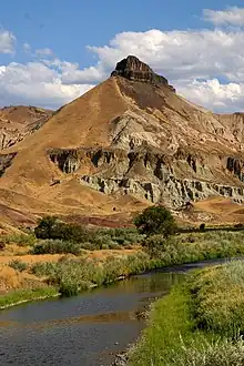
John Day River ved Sheep Rock i John Day Fossil Beds nationalmonument.
| John Day River | |
| River | |
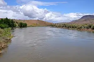 John Day River ved Clarno. | |
| Etymologi: John Day, en pelsjæger og -handler [1] | |
| Land | USA |
|---|---|
| Delstat | Oregon |
| Bifloder | |
| - venstre | South Fork John Day River |
| - højre | North Fork John Day River |
| Udspring | Strawberry Mountains |
| - sted | Malheur National Forest, Grant County |
| - højde | 2.036 moh |
| - koord. | 44.245439°N 118.5521617°V |
| Udmunding | Columbia River |
| - koord. | 45.7326252°N 120.6492244°V |
| Længde | 457 km[2][3] |
| Afvandingsomr. | 20.720 km²[3] |
| Vandføring | |
| - middel | 59 m³/s[4] |
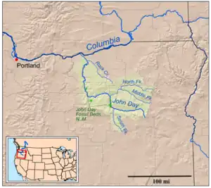 John Day Rivers afvandingsområde. John Day Rivers afvandingsområde.
| |
| Wikimedia Commons: John Day River | |
Se også
Eksterne kilder/henvisninger
- Topinka, Lyn. "John Day River, Oregon". Columbia River Images. Hentet 6. juli 2013.
- "John Day River". Oregon Environmental Council. Arkiveret fra originalen 4. maj 2013. Hentet 6. juli 2013.
- "John Day Subbasin Plan", p. 18
- "Water-Data Report 2012: 14048000 John Day River at McDonald Ferry, OR" (PDF). U.S. Geological Survey. Hentet 6. juli 2013.
This article is issued from Wikipedia. The text is licensed under Creative Commons - Attribution - Sharealike. Additional terms may apply for the media files.