Vomano
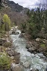
Vomano (latin: Vomanus)[1] er en 76 km lang flod, der løber i regionen Abruzzo i Italien. Dens udspring er nær Monte San Franco ved Gran Sasso d'Italia og Lago di Campotosto i provinsen L'Aquila. Floden løber ind i provinsen Teramo og løber mod nordøst ved Montorio al Vomano og Basciano. Floden Fucino løber ind i Vomano syd for Crognaleto og Mavone løber ind i Vomano nær Basciano.[2] Den løber ud i Adriaterhavet i nærheden af Roseto degli Abruzzi.
| Vomano | |
|---|---|
 | |
| Overblik | |
| Land | Italien |
| Geografi | |
| Udspring | Monte San Franco - Gran Sasso d'Italia |
- højde | 2.120 moh. |
| Udmunding | Adriaterhavet nær Roseto degli Abruzzi |
| Fysiske kendetegn | |
| Længde | 76 km |
| Afvandingsareal | 764 km² |
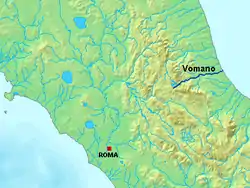 | |
| Vomano indtegnet i det centrale Italien< | |
I 1995 blev en stor del af flodens afvandingsområde udlagt som naturpark under navnet Parco territoriale attrezzato del Fiume Vomano.[3][4]
Referencer
- Richard J.A. Talbert, red. (2000). Barrington Atlas of the Greek and Roman World: Map-By-Map Directory. Vol. I. Princeton, NJ and Oxford, UK: Princeton University Press. s. 613. ISBN 0691049459.
- The Times Comprehensive Atlas of the World (13 udgave). London: Times Books. 2011. s. 77 M2. ISBN 9780007419135.
- Parco territoriale attrezzato del Fiume Vomano
- Area protetta via web.archive.org
| | Spire Denne artikel om italiensk geografi er en spire som bør udbygges. Du er velkommen til at hjælpe Wikipedia ved at udvide den. |
This article is issued from Wikipedia. The text is licensed under Creative Commons - Attribution - Sharealike. Additional terms may apply for the media files.