Barnstable County
Barnstable County er et county i den amerikanske delstat Massachusetts. Barnstable County ligger i de sydøstlige del af delstaten og grænser op til Plymouth County i nordvest og mod Dukes County i syd.
| Barnstable County, Massachusetts | |
| Kort | |
 Placering i delstaten Massachusetts | |
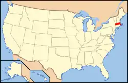 Massachusettss placering i USA | |
| Basis data | |
| Grundlagt | 1685 |
|---|---|
| Hovedby | Barnstable |
| Største by | Barnstable |
| Areal - I alt - Land - Vand |
3.382 km² 1.024 km² 2.357 km² |
| Befolkningstal - år 2010 Befolkningstæthed |
216.902 210 indb/km² |
| Hjemmeside: www.barnstablecounty.org | |
Barnstable Countys totale areal er 3.382 km² hvoraf 2.357 km² er vand. I 2000 havde Barnstable County 222 230 indbyggere. Det administrative centrum ligger i byen Barnstable.
Counties i delstaten Massachusetts | ||
|---|---|---|
This article is issued from Wikipedia. The text is licensed under Creative Commons - Attribution - Sharealike. Additional terms may apply for the media files.