Hohenwarth (Landkreis Cham)
Hohenwarth er en kommune i Regierungsbezirk Oberpfalz i den østlige del af den tyske delstat Bayern, med godt 2.000 indbyggere.
| Hohenwarth | |
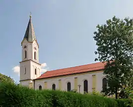 Kirke i Hohenwarth | |
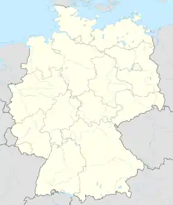
| Våben | Beliggenhed |
.svg.png.webp) Coat of arms of Hohenwarth |
 |
| Administration | |
| Land | |
|---|---|
| Delstat | Bayern |
| Admin. region | Oberpfalz |
| Kreis | Landkreis Cham |
| Borgmester | Franz Xaver Gmach |
| Statistiske data | |
| Areal | 24,23 km² |
| Højde | 507 m |
| Indbyggere | 1.912 (31/12/2018) |
| - Tæthed | 79 Indb./km² |
| Andre informationer | |
| Tidszone | CET/CEST (UTC+1/UTC+2) |
| Nummerplade | CHA |
| Postnr. | 93480 |
| Tlf.-forvalg | 0 99 46 |
| Koordinater | 49°12′N 12°56′Ø |
| Hjemmeside | www.hohenwarth.de
|
Geografi
Hohenwarth ligger i Bayerischen Wald.
Landsbyer og bebyggelser
|
|
| ||
| Wikimedia Commons har medier relateret til: |
This article is issued from Wikipedia. The text is licensed under Creative Commons - Attribution - Sharealike. Additional terms may apply for the media files.