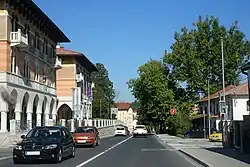
Ilirska Bistrica
Ilirska Bistrica er en by i det sydvestlige Slovenien med et indbyggertal på ca. 4.323 (2020)[1] indbyggere.
| Ilirska Bistrica Ilirska Bistrica | |||
|---|---|---|---|
| |||
 | |||
| Overblik | |||
| Land |
| ||
| Postnr. |
6250 | ||
| Nummerpladebogstav(er) |
KP | ||
| UN/LOCODE |
SIIBS | ||
| Demografi | |||
| Indbyggere |
4.323 (2020)[1] | ||
| - Areal | 480 km² | ||
| - Befolkningstæthed | 9,01 pr. km² | ||
| Andet | |||
| Tidszone |
UTC+1 (normaltid) UTC+2 (sommertid) | ||
| Højde m.o.h. |
172 m, 897 m | ||
| Hjemmeside | www.ilirska-bistrica.si | ||
| Oversigtskort | |||
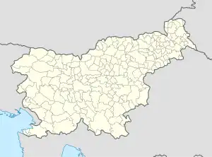 Ilirska Bistrica Ilirska Bistricas beliggenhed i Slovenien 45°33′54″N 14°14′56″Ø | |||
Byen ligger i floden Rekas floddal tæt på grænsen til Kroatien.
Referencer
- Prebivalstvo - izbrani kazalniki, naselja, Slovenija, letno, Statistical Office of the Republic of Slovenia, hentet 28. april 2021 (fra Wikidata).
Eksterne henvisninger
Store byer i Slovenien | ||
|---|---|---|
| | Spire Denne artikel om Sloveniens geografi er en spire som bør udbygges. Du er velkommen til at hjælpe Wikipedia ved at udvide den. |
This article is issued from Wikipedia. The text is licensed under Creative Commons - Attribution - Sharealike. Additional terms may apply for the media files.