Ashanti (region)
| Ashanti | ||
| Provins | ||
 Gadebillede fra regionshovedstaden Kumasi | ||
|
||
| Land | ||
|---|---|---|
| Hovedby | Kumasi | |
| Areal | 24.389 km² | |
| Indbyggertal | 3.612.950 (2006) | |
| - tæthed | 148,14 | |
 Ashanti (region) Ashanti (region)
| ||
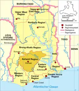
Ashanti er en administrativ region beliggende centralt i Ghana med regionshovedstad i byen Kumasi. Den grænser med nord nordvest til regionen Brong-Ahafo, mod syd til Central-regionen, mod sydvest ril Western-regionen og mod øst til Eastern-regionen. Hovedparten af regionens indbyggere er fra ashantifolket, der er en af Ghanas største etniske grupper. Store dele af landets produktion af kakao dyrkes i Ashanti, og regionen er også en vigtig del af Ghanas guldgravningsindustri. Kratersøen Bosumtwi ligger i regionen.
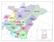
Ashantis distrikter
Regionen Ashanti er inddelt i følgende 21 distrikter:
- Adansi North District
- Adansi South District
- Afigya-Sekyere District
- Ahafo Ano North District
- Ahafo Ano South District
- Amansie Central District
- Amansie East District
- Amansie West District
- Asante Akim North District
- Asante Akim South District
- Atwima Mponua District
- Atwima Nwabiagya District
- Botsomtwe/Atwima/Kwanhuma District
- Ejisu-Juaben District
- Ejura/Sekyedumase District
- Kumasi Metropolitan District
- Kwabre District
- Obuasi Municipal District
- Offinso District
- Sekyere East District
- Sekyere West District
| | Spire Denne artikel om ghanesisk geografi er en spire som bør udbygges. Du er velkommen til at hjælpe Wikipedia ved at udvide den. |
This article is issued from Wikipedia. The text is licensed under Creative Commons - Attribution - Sharealike. Additional terms may apply for the media files.