Eastern (Ghana)
| Eastern | ||
| Provins | ||
|
||
| Land | ||
|---|---|---|
| Hovedby | Koforidua | |
| Areal | 19.323 km² | |
| Indbyggertal | 2.106.696 (2000) | |
| - tæthed | 109,03 | |
 Eastern (Ghana) Eastern (Ghana)
| ||
.gif)
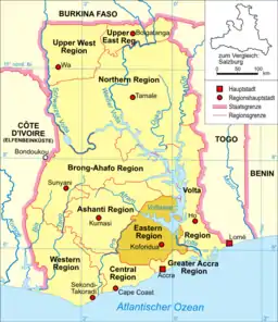
Eastern Region er en af Ghanas ti administrative regioner og den administrative hovedstad er byen Koforidua. Regionen ligger i den sydøstlige dela f landet og grænser mod nord til regionen Brong-Ahafo mod sydvest til Centralregionen, mod sydøst til Greater Accra , mod vest til Ashanti og mod øst til Volta.
Distrikter

Eastern Regions distrikter
Eastern Region deles inn i følgende 13 distrikter:
- Afram Plains District
- Akuapim North District
- Akuapim South District
- Asuogyaman District
- Atiwa District
- Birim North District
- Birim South District
- East Akim District
- Fanteakwa District
- Kwaebibirem District
- Kwahu South District
- Kwahu West District
- Manya Krobo District
- New-Juaben Municipal District
- Suhum/Kraboa/Coaltar District
- West Akim District
- Yilo Krobo District
| | Spire Denne artikel om ghanesisk geografi er en spire som bør udbygges. Du er velkommen til at hjælpe Wikipedia ved at udvide den. |
This article is issued from Wikipedia. The text is licensed under Creative Commons - Attribution - Sharealike. Additional terms may apply for the media files.