Blue Earth County
Blue Earth County er et county i den amerikanske delstat Minnesota. Amtet ligger i de sydlige del af delstaten og grænser op mod Nicollet County i nord, Le Sueur County i nordøst, Waseca County i øst, Faribault County i syd, Martin County i sydvest, Watonwan County i vest og mod Brown County i nordvest.
| Blue Earth County, Minnesota | |
| Kort | |
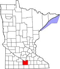 Placering i delstaten Minnesota | |
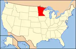 Minnesotas placering i USA | |
| Basis data | |
| Grundlagt | 1853 |
|---|---|
| Hovedby | Mankato |
| Største by | Mankato |
| Areal - I alt - Land - Vand |
1,984 km² 1,949 km² 35 km² |
| Befolkningstal - år 2010 Befolkningstæthed |
64,013 29 indb/km² |
| Hjemmeside: www.co.blue-earth.mn.us | |
| Opkaldt efter: Blue Earth River | |
Blue Earth Countys totale areal er 1 984 km² hvoraf 35 km² er vand. I 2000 havde amtet 55 941 indbyggere. Amtets administration ligger i byen Mankato som også er amtets største by.
Eksterne henvisninger
| | Spire Denne artikel om USA's geografi er en spire som bør udbygges. Du er velkommen til at hjælpe Wikipedia ved at udvide den. |
This article is issued from Wikipedia. The text is licensed under Creative Commons - Attribution - Sharealike. Additional terms may apply for the media files.