Rice County (Minnesota)
Rice County er et county i den amerikanske delstat Minnesota. Rice County ligger i den sydøstlige del af delstaten og grænser op til Dakota County i nordøst, Goodhue County i øst, Dodge County i sydøst, Steele County i syd, Waseca County i sydvest, Le Sueur County i vest og mod Scott County i nordvest.
 For alternative betydninger, se Rice County. (Se også artikler, som begynder med Rice County)
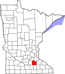
Rice Countys beliggenhed i Minnesota
Rice Countys totale areal er 1.337 km², hvoraf 48 km² er vand. I 2000 havde Rice County 56.665 indbyggere. Administrativt centrum er i byen Faribault som også er county'ets største by.
Rice County har fået sit navn efter senator Henry Mower Rice.
This article is issued from Wikipedia. The text is licensed under Creative Commons - Attribution - Sharealike. Additional terms may apply for the media files.