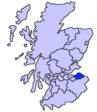
East Lothian
East Lothian, som også går under navnet Haddingtonshire er en af Skotlands kommuner. Det grænser op mod City of Edinburgh, Scottish Borders og Midlothian. Administrationscenteret er Haddington, og den største by er Musselburgh.
| East Lothian | |
|---|---|
 | |
| Geografi | |
| Areal: - Totalt - % vand | 679 km² ? % |
| Adm. center | Haddington |
| ISO 3166-2-kode: | GB-ELN |
| ONS-kode: | 00QM |
| Demografi | |
| Befolkning: - Totalt (29. april 2001) - Tæthed | 90 088 133 / km² |
| Grevskabet East Lothian | |
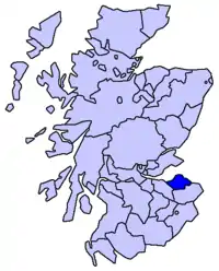 | |
Grevskabet East Lothian grænser op mod Midlothian og Berwickshire.
Byer og landsbyer
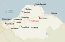
Byer og landsbyer i East Lothian
- Aberlady
- Athelstaneford
- Auldhame
- Ballencrieff
- Bara
- Belhaven
- Biel
- Bilsdean
- Bolton
- Broxburn
- Canty Bay
- Cockenzie
- Dirleton
- Drem
- Dunbar
- Dunglass
- East Fortune
- East Linton
- East Saltoun
- Elphinstone
- Fenton Barns
- Fisherrow (historisk i Midlothian)
- Garvald
- Gifford
- Gladsmuir
- Glenkinchie
- Gullane
- Haddington
- Humbie
- Innerwick
- Inveresk (historisk i Midlothian)
- Kingston
- Longniddry
- Luffness
- Macmerry
- Markle
- Monktonhall (historisk i Midlothian)
- Musselburgh (historisk i Midlothian)
- North Berwick
- Oldhamstocks
- Ormiston
- Peaston
- Pencaitland
- Phantassie
- Port Seton
- Preston
- Prestonpans
- Samuelston
- Scoughall
- Spittal
- Spott
- Stenton
- Tranent
- Tyninghame
- Wallyford (historically within Midlothian)
- West Barns
- West Saltoun
- Whitecraig (historically within Midlothian)
- Whitekirk and Tyninghame
- Whittingehame
Seværdigheder
- Aberlady Bay
- Bass Rock
- Dirleton Castle
- Dunglass Collegiate Church
- Fa'side Castle
- Fenton Barns Retail & Leisure Village
- Hailes Castle
- Hopetoun Monument
- Lennoxlove historic house
- Longniddry Bents
- Muirfield Golf Links
- Museum of Flight, East Fortune
- North Berwick Harbour
- North Berwick Law
- Preston Mill
- Prestongrange Industrial Heritage Museum
- Scottish Seabird Centre, North Berwick
- Seacliff Beach
- Seton Collegiate Church
- Tantallon Castle
- Chesters Hill Fort
- Torness Nuclear Power Station
- Traprain Law
- Yellowcraigs
Eksterne henvisninger
- East Lothian Courier: Den lokale avis Arkiveret 29. oktober 2006 hos Wayback Machine (engelsk)
| | Spire Denne artikel om Skotlands geografi er en spire som bør udbygges. Du er velkommen til at hjælpe Wikipedia ved at udvide den. |
| | Infoboks uden skabelon Denne artikel har en infoboks dannet af en tabel eller tilsvarende. |
This article is issued from Wikipedia. The text is licensed under Creative Commons - Attribution - Sharealike. Additional terms may apply for the media files.