North Lanarkshire
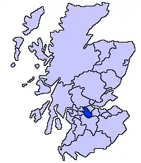
North Lanarkshire (skotsk: North Lanrikshire; skotsk gælisk: Siorrachd Lannraig a Tuath) er en af Skotlands kommuner. Den grænser op mod City of Glasgow, Falkirk, East Dunbartonshire og South Lanarkshire.
| North Lanarkshire | |
|---|---|
 | |
| Geografi | |
| Areal: - Totalt - % vand | 470 km² ? % |
| Adm. center | Motherwell |
| ISO 3166-2-kode: | GB-NLK |
| ONS-kode: | 00QZ |
| Demografi | |
| Befolkning: - Totalt (29. april 2001) - Tæthed | 321 067 683 / km² |
Regionen dækker dele af de grevskaberne Lanarkshire, Dunbartonshire og Stirlingshire.
Byer og landsbyer
Byer
- Airdrie
- Bellshill
- Coatbridge
- Cumbernauld
- Kilsyth
- Mossend
- Motherwell
- Shotts
- Stepps
- Viewpark
- Wishaw
Landsbyer
- Allanton
- Auchinloch
- Annathill
- Banton
- Bargeddie
- Birkenshaw
- Bonkle
- Cardowan
- Calderbank
- Caldercruix
- Carfin
- Carnbroe
- Castlecary
- Chapelhall
- Chryston
- Cleland
- Croy
- Dullatur
- Garnkirk
- Gartcosh
- Glenboig
- Glenmavis
- Greengairs
- Hareshaw
- Harthill
- Hartwood
- Holytown
- Longriggend
- Luggiebank
- Millerston
- Mollinsburn
- Moodiesburn
- Morningside
- Muirhead
- Newarthill
- Newhouse
- Newmains
- New Stevenston
- Overtown
- Plains
- Queenzieburn
- Ravenscraig
- Salsburgh
- Tannochside
- Wattston
- Upperton
Seværdigheder
- Airdrie Public Observatory
- Bedlay Castle
- Carfin Grotto
- Clyde Valley
- Colzium
- Dalzell House
- Dalziel Park
- Drumpellier Country Park
- Duncarron
- Greenlink Cycle Path
- Jerviston
- Newhouse Research Site
- North Lanarkshire Heritage Centre
- Ravenscraig Regional Sports Facility
- Summerlee Museum of Scottish Industrial Life
- Strathclyde Country Park
| | Spire Denne artikel om Skotlands geografi er en spire som bør udbygges. Du er velkommen til at hjælpe Wikipedia ved at udvide den. |
| | Infoboks uden skabelon Denne artikel har en infoboks dannet af en tabel eller tilsvarende. |
This article is issued from Wikipedia. The text is licensed under Creative Commons - Attribution - Sharealike. Additional terms may apply for the media files.